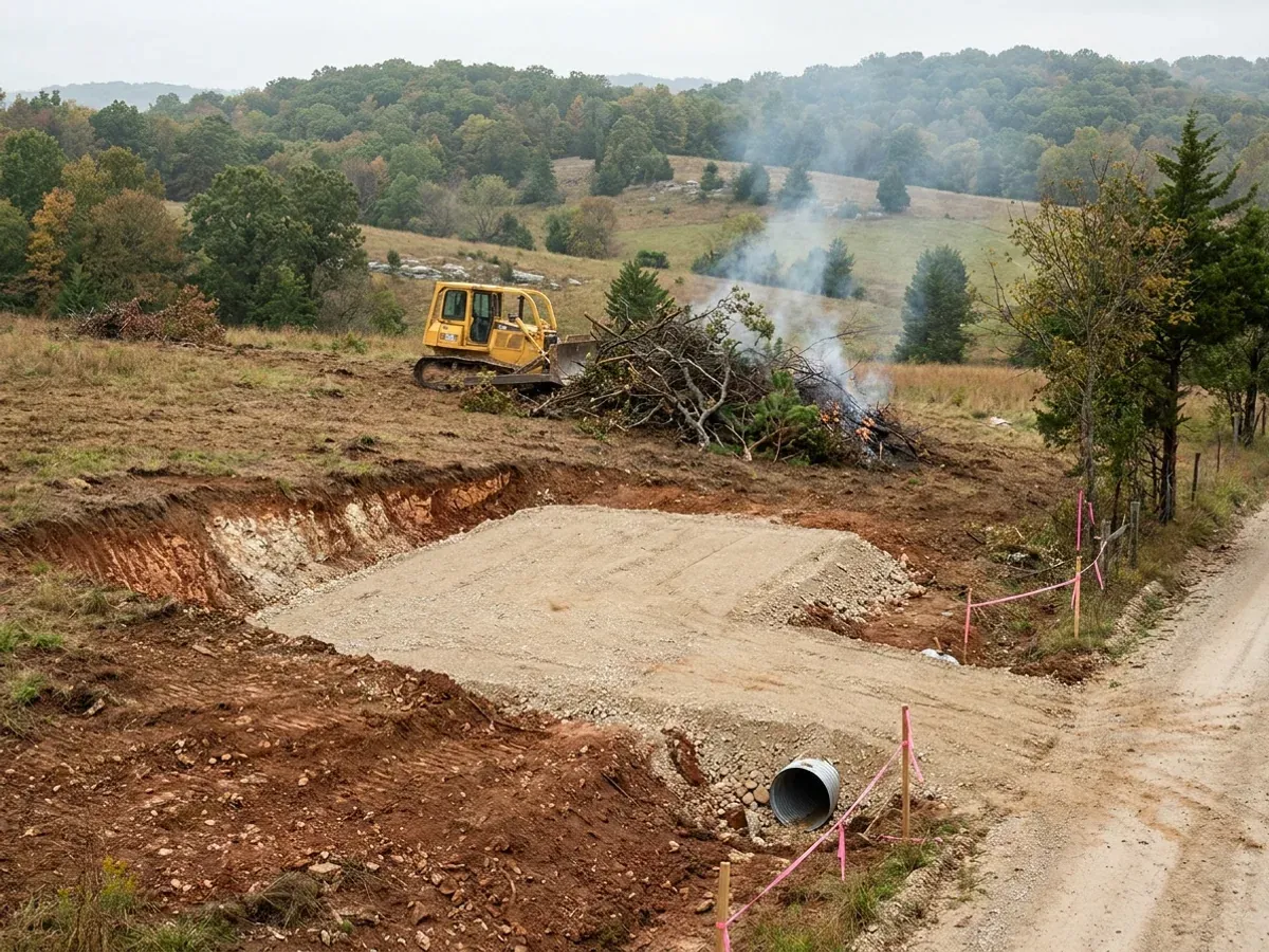
A dozer clearing brush on a rural parcel beside a compacted crushed-stone building pad, with red clay exposed in the cut and a culvert set at the driveway entrance.

Site Preparation in Missouri

Everything expensive that goes wrong on a barndominium goes wrong below the slab. Site prep is clearing and grubbing, cut and fill, a compacted pad, drainage, the culvert and driveway, and getting power, water and wastewater to the building. Missouri front-loads one decision that prior states did not: the wastewater site evaluation is not automatically a percolation test. Under 19 CSR 20-3.060 two kinds of site evaluation are acceptable — percolation tests, or a soil morphology examination in a profile pit — and the administrative authority decides which is used. Perc-test-only is available solely where the site is not classified as having significant groundwater contamination potential, and only percolation rates between ten and sixty minutes per inch are acceptable at all. In Ozark karst and on northern Missouri claypan — the two grounds a barndominium is most likely to sit on — that route is either closed or useless. So this starts with soil, not with a machine.

Permit-ready stamped drawings
Engineered for what your county actually requires

Site Preparation: how the work runs

Four stages, in this order. The sequence matters more than it looks: getting engineering and permitting settled before anything is fabricated is what keeps a build from stalling.

1

Boundary, topography and legal access

Before any dirt moves, three things need settling on paper: where the lines are, how the ground falls, and how you get onto the parcel legally. A licensed land surveyor locates the corners and sets the topography; that work is a licensed profession in Missouri and it is procured as such. Access is a separate question with three different answers. A new entrance onto a state route is a MoDOT permit, requested through MoDOT's electronic permitting system and governed by its Engineering Policy Guide Category 941, where a house driveway is a Type I Residential Driveway. A county road is the county's own permit — Johnson County's Road and Bridge Department runs the cleanest published triage in the state, and its test is the sign: green numbered signs mark county roads and need a county permit, brown numbered signs mark private roads and need an arrangement with the owners. Nothing gets scheduled before the access answer is in hand.

2

The soil and wastewater evaluation

Missouri registers two different professionals for this and the rule treats their work as measuring different things. A percolation tester measures rate; an on-site soil evaluator reads soil morphology in a profile pit. Under 19 CSR 20-3.060 the administrative authority decides which method is used, and percolation testing alone is available only where the site is not classified as having significant groundwater contamination potential — a classification that expressly catches a disposal field within a hundred feet of the topographic drainage of a sinkhole, a sewage tank within fifty feet of one, and soils that perc faster than ten minutes per inch. Rates slower than sixty minutes per inch push the design onto a registered engineer's drawing; slower than a hundred and twenty and no conventional on-site system may be permitted at all. This is the step that decides whether the parcel supports the house you have drawn, and it is worth doing before the land is bought rather than after.

3

Karst, claypan and the pad

Two grounds dominate this build type in Missouri and they fail in opposite directions. In the Ozarks the rock dissolves: the Department of Natural Resources' own sinkhole layer carried 16,001 mapped points as of 5 September 2026, DNR states approximately 7,500 recorded caves statewide, and its own guidance is blunt — "once sinkholes form, they do not go away," and a property owner should contact a professional engineer or a registered geologist for help stabilising one. Across northern and central Missouri the problem is water that will not leave: the USDA's official description of the Mexico series, the state's signature claypan, records very slow permeability and a perched water table with an upper limit between roughly half a foot and a foot and a half below the surface from December to May in most years. Cut and fill to design elevation, then a compacted pad tested to spec, is the same sentence on both — but the drainage strategy under it is not.

4

Drainage, flood status and utilities to the pad

Swales and culverts so water leaves the building, then power, water and the wastewater system stubbed to the pad. Two Missouri checks belong here rather than later. If any part of the site is in a mapped Special Flood Hazard Area, the permit comes from the local floodplain administrator of a participating community — and FEMA's own guidance for Missouri is explicit that farm houses are not agricultural structures, so the exemptions people expect to shelter a barndominium in the bottoms do not. On the water side, Missouri's well rules define thirteen drilling areas based on geology, groundwater hydrology, water quality and drilling conditions, and the drilling area is what sets how much casing the well needs — so well cost is a mapped variable, not a builder's guess. A permitted driller files the water well report with the department's Well Installation section in Rolla within sixty days and the certification number is mailed to the owner.
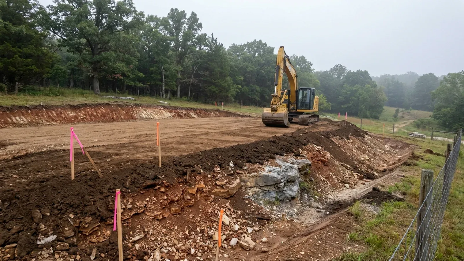
An excavator grading a compacted building pad on a cleared lot, with survey stakes and a drainage swale visible.
The test that is not a perc test

Missouri lets the permitting authority choose between a percolation test and a soil pit — and on the ground a barndominium usually sits on, it will not choose the perc test

Almost every piece of national barndominium advice assumes a percolation test. Missouri's on-site sewage rule, 19 CSR 20-3.060, says two types of site evaluation are acceptable and that the administrative authority will determine which method is to be used. The first is percolation testing, and the rule fences it in hard: it may be used only for siting and sizing standard systems in areas not classified as having significant groundwater contamination potential, only percolation rates between ten and sixty minutes per inch are acceptable, and a minimum of four test holes are required with the slowest of the four governing the design. The second is a soil morphology examination, and the rule requires a profile pit for all new installations in order to conduct one. Now read the classification that closes the first door. "Significant groundwater contamination potential" is defined to include a disposal field within one hundred feet of the topographic drainage of a sinkhole, a sewage tank within fifty feet of one, and soils that perc faster than ten minutes per inch. Cherty, fast-draining Ozark ground fails on rate. Sinkhole country fails on proximity — and the Department of Natural Resources' own layer carries sixteen thousand mapped sinkhole points. Northern Missouri claypan fails from the other end, on permeability the USDA itself describes as very slow. The right phrase for Missouri is a soil morphology evaluation, with a percolation test if the local authority allows one — never "a perc test" on its own.

Where we deliver site preparation

In Missouri the county line is a real boundary, and unusually it can decide whether there is a building code on your side of it at all. Only first- and second-classification counties may adopt one, and classification is set by assessed valuation rather than population — so a small county can have the authority while a much larger one does not. Cross a line and what changes is whether the build is inspected, who reviews the drawings, what they charge, how the land is zoned, and the design figures the work is engineered to. Two parcels twenty miles apart can carry completely different engineering, and sometimes completely different paperwork.

Serving clients across the entire region.

Every locality we build in has its own reviewer, its own fee schedule and its own filled-in design criteria. The service area pages set out what each one publishes.

View our full service area →
Before you commit

What actually decides the price

Square footage is the number everyone leads with, and it is rarely the one that moves a barndominium budget. These four do.

  • Which site evaluation your ground qualifies for

    A percolation test and a soil morphology examination in a profile pit are different jobs done by differently registered people, and under 19 CSR 20-3.060 the administrative authority chooses. The perc-only route is available solely where the site is not classified as having significant groundwater contamination potential and only where rates fall between ten and sixty minutes per inch. Slower than sixty and the design has to be drafted and signed by a registered engineer; slower than a hundred and twenty and no conventional on-site system may be permitted at all. That is not a fee difference. It is the difference between a parcel that takes a standard system and one that takes a designed and signed drawing before anything can be permitted at all.

  • Whether the lot is three acres or more

    RSMo 701.031 excludes the owner of a single-family residence lot of three acres or more from the state's on-site sewage provisions entirely — with three limits that matter. It is an exemption from the state programme only, and a county ordinance under RSMo 701.035 or 701.047 can still reach the same parcel and may be more restrictive than the state. It removes the permit, not the duty: the same section opens by requiring property owners of all buildings where people live, work or assemble to provide for the sanitary disposal of all domestic sewage, and it attaches conditions of its own, including every point of the system being more than ten feet from any adjoining property line. And lots adjacent to lakes operated by the Corps of Engineers or by a public utility are expressly carved back out.

  • Karst, if any part of a sinkhole touches the site

    In Greene County this is a written standard rather than a judgement call. The county's Design Standards Section 107, adopted 5 April 1999, requires a Sinkhole Evaluation Report for all development sites on which sinkholes are fully or partially located, containing a site plan, an area map, a flooding evaluation and a water-quality evaluation. Its policy leads with avoidance: construction in sinkholes is to be avoided, with exceptions only where it can be conclusively demonstrated there is no practical alternative. A residential structure may be permitted within the sinkhole rim if it is set back at least twenty feet from the sinkhole flooding area, with the lowest floor at least five feet above the sinkhole flooding elevation or one foot above the lowest point on the rim, whichever is less — and only with a statement from a qualified engineer that foundation conditions are suitable.

  • Access, haul distance and what the utilities have to cross

    A new entrance onto a state route is a MoDOT permit; a county road is the county's; a private road is an agreement with whoever owns it. Beyond the entrance, distance is the number that moves: how far the pad sits from the existing road, from the transformer and from the well. Missouri's well rules define thirteen drilling areas based on geology, groundwater hydrology, water quality and drilling conditions, and the drilling area sets the casing — which is why the same well is a different price twenty miles away, and why the drilling area gets looked up before a budget is written rather than after.

A dozer clearing brush on a rural parcel beside a compacted crushed-stone building pad, with red clay exposed in the cut and a culvert set at the driveway entrance.

Site Preparation in Missouri: common questions

8 questions we get asked most often about building in Missouri. If yours is not on the list, ask it directly.

Do I need a perc test to build in Missouri?
Not necessarily, and assuming so is the most common mistake carried into Missouri from other states. The state's minimum construction standards for on-site sewage disposal systems, 19 CSR 20-3.060, provide that two types of site evaluation are acceptable and that the administrative authority will determine which method is to be used. Percolation testing alone can be used only for siting and sizing standard systems in areas not classified as having significant groundwater contamination potential, and only percolation rates between ten and sixty minutes per inch are acceptable. Four test holes are required — three around the periphery of the proposed absorption area and one in the middle — and the slowest of the four governs the design. The alternative is a soil morphology examination, for which the rule requires a profile pit on all new installations, and where that route is used no percolation test is required, though the authority may still ask for one. Missouri registers both roles separately: 19 CSR 20-3.080 is titled "Requirements for Percolation Testers, On-Site Soils Evaluators and Registered On-Site Wastewater Treatment System Installers." The correct question to ask your permitting authority is not "how much is a perc test" but "which evaluation will you accept on this parcel."
My lot is over three acres. Do I still need a septic permit?
Possibly not from the state — and this is commercially the most significant fact in Missouri for this building type, because a barndominium parcel is very often three acres or more. RSMo 701.031 excludes the owner of a single-family residence lot consisting of three acres or more from the provisions of sections 701.025 to 701.059 and the rules made under them, including the provisions on construction, operation, major modification and major repair. There is a parallel exclusion for a residential lot of ten acres or more with no single-family residence on-site system within three hundred sixty feet of any other, and no more than one residence per ten acres in the aggregate. Three limits travel with it and all three matter. First, it is an exemption from the state programme only — a county ordinance made under RSMo 701.035 or 701.047 can still reach the parcel, and those sections expressly allow a county to be more restrictive than the state. Second, it removes the permit, not the duty: the same section opens by requiring property owners of all buildings where people live, work or assemble to provide for the sanitary disposal of all domestic sewage, and the exemption itself is conditioned on every point of the system being more than ten feet from any adjoining property line and on no effluent entering adjoining property, contaminating surface water or groundwater, or creating a nuisance. Third, lots adjacent to lakes operated by the Corps of Engineers or by a public utility are expressly carved back out — which in Missouri means shoreline parcels need checking one at a time. The right first move is the Department of Health and Senior Services' own county selector, which resolves every Missouri county to one of three authority types: the DHSS onsite programme, a local authority under contract, or a local authority under its own ordinance.
There's a sinkhole on or near the land. What does that do to the build?
Three separate things, and only one of them is about the foundation. First, position: the Department of Natural Resources publishes the state sinkhole inventory as a live map layer through its GeoSTRAT tool, and that layer carried 16,001 mapped points as of 5 September 2026 — pull the parcel before you buy, not after. DNR is candid that the inventory is not complete and that some sinkholes "are not readily visible on the surface because voids are plugged or capped with soil or thin layers of rock," and that such voids "may be discovered during excavation, by drilling, or through geophysical exploration." Second, wastewater: Missouri's on-site sewage rule classifies a site as having significant groundwater contamination potential where a disposal field would sit within a hundred feet of the topographic drainage of a sinkhole, or a sewage tank within fifty feet — and that classification removes the percolation-test-only route and sends the site to a soil morphology evaluation. Karst is not an aesthetic problem in Missouri; it changes the legal method of evaluating the septic site. Third, the local rule, which is genuinely county-specific. Greene County's Design Standards Section 107, adopted 5 April 1999, requires a Sinkhole Evaluation Report for any development site on which sinkholes are fully or partially located, sets residential setbacks from the sinkhole flooding area and floor elevations above the flooding elevation, and requires a statement from a qualified engineer that foundation conditions are suitable. DNR's own advice on any sinkhole is to bring in a professional engineer or a registered geologist, and its bluntest line is worth remembering: "once sinkholes form, they do not go away."
How do I find out what my soil actually is before I commit?
Missouri has complete modern digital soil survey coverage, which is not true everywhere, so the answer is free and takes an afternoon. A query of the USDA-NRCS Soil Data Access service on 5 September 2026 returned 114 published soil survey areas for Missouri, every one carrying a 2025 refresh date, with St. Louis County and St. Louis City covered by a single area — so every county plus the independent city is mapped. The public front end is Web Soil Survey, and it will give you the map units under your parcel. What to look for depends on where you are. Across northern and central Missouri the signal is claypan: the same Soil Data Access query found the recognised Central Claypan series — Mexico, Putnam, Adco, Leonard and Armstrong — as major map-unit components in 38 Missouri counties, with the fullest suite concentrated in the northeast. The USDA's official description of the Mexico series tells you what that means without any inference: very deep, poorly drained, formed in loess over loamy sediments; classified as a smectitic, Vertic soil, which is the shrink-swell mineralogy stated in the taxonomy itself; permeability very slow; and in undisturbed areas a perched water table with an upper limit between about half a foot and a foot and a half below the surface from December to May in most years. That drives two decisions at once — the slab and drainage above, and the drainfield below. Missouri's own sewage rule adds a fair warning about survey data: it says NRCS county soil survey reports "should not be used as sole final determination for a specific site, only as a guide."
How deep do the footings and post holes have to go?
To the depth published by the jurisdiction that will review the drawings — and in Missouri those published depths move by half again. The City of Springfield's 2018 IRC adoptive ordinance prints a 24-inch frost line depth. Boone County's 2015 International Code Addendums print 30 inches, and St. Charles County's 2021 residential code also prints 30. On a post-frame building that number sets the depth of every hole on the site, which makes it the single most consequential figure in this whole conversation. The City of St. Louis names the ways around its own depth, amending R403.1.4.1 so frost protection may be met by going 30 inches below finished grade, by a frost-protected shallow foundation under R403.3, by ASCE 32-01, or by erecting on solid rock; the City of Sullivan keeps the solid-rock alternative too. Springfield carried a comparable amendment until Gen. Ord. 6736 repealed and replaced its residential code article on 1 January 2023; the article that replaced it does not amend R403 at all. In the Ozarks that last option is not a technicality — shallow dolomite is common and nobody benefits from thirty inches of rock excavation per hole. Two things not to do. Do not accept a builder's statement of "the Missouri frost depth," because there is no such figure. And do not take the frost depth from the only frost map a Missouri state agency publishes: that map is the Public Service Commission's 2016 map for manufactured-home installation, and the Commission prints its own caveat on it that "some local jurisdictions may require the footing(s) to be at a greater depth than what is required by the PSC."
My land is in the floodplain, or behind a levee. What changes?
Quite a lot, and one Missouri wrinkle catches people who have built in other states. Inside a Special Flood Hazard Area the permit comes from the local floodplain administrator of a participating community, and in unincorporated territory the county is the community, acting under its own adopted floodplain management ordinance. FEMA and SEMA's Missouri guide lists construction of agricultural buildings among the activities requiring that permit, requires a permit before those and any land-disturbing activities, notes that non-elevated agricultural structures may be permitted only by variance — and then says the sentence that decides this building type: "Farm houses are NOT agricultural structures." So a barndominium in a mapped flood hazard area is variance territory, not exemption territory. The Missouri wrinkle is who gets to decide whether the county has floodplain rules at all. RSMo 49.600 provides that in a county that has not adopted county planning and zoning, no order or ordinance adopting National Flood Insurance Program regulations is effective unless the county's voters authorise it — and voters can rescind it afterwards on a petition signed by five percent of those who voted at the last gubernatorial election, with the programme discontinued within thirty days of certification. Participation is therefore genuinely uneven: FEMA's Community Status Book for Missouri, in a report dated 5 September 2026, listed 693 Missouri communities in the flood programme and 192 not in it — with every one of those 192 carrying a FEMA-identified flood hazard area. On levees, SEMA's own state hazard mitigation plan is worth quoting to anyone who tells you a bottomland parcel is protected: non-federal levees, predominantly protecting agricultural land, "are frequently designed for a flood with a return period of 50 years or less."
Who issues the driveway permit, and does it really matter?
It matters because it is one of the few approvals in rural Missouri that genuinely bites, and because the answer depends on who owns the road rather than on where you are. If the entrance comes off a state route, it is MoDOT: a permit is required for a new driveway and for changes to an existing one in width, grade, location or surface type, requested through MoDOT's electronic permitting system and governed by its Engineering Policy Guide Category 941, which covers sight distance, traffic impact and entrance design. In MoDOT's entrance taxonomy a house driveway is a Type I Residential Driveway. If the road is a county road, it is the county's permit, and there is no statewide instrument — this is county by county. Johnson County publishes the clearest version of the test and it is worth carrying anywhere in the state: state routes go to MoDOT, city streets go to city hall, county roads marked with green numbered signs need a county permit from Road and Bridge, and private roads marked with brown numbered signs need an arrangement with the owners rather than a permit at all. Sight distance is the item that most often forces the entrance to move, which is why this is settled before the pad location is fixed rather than after.
What about the well and getting power to the building?
Both are simpler than people fear on paperwork and harder than people expect on geology. On the well: Missouri's permit is an occupational permit held by the driller and pump installer, not a permit for your well. The Department of Natural Resources states that landowners who drill their own well or install their own pump are exempt from permit requirements but must still follow all other sections of the rules. The driller files a water well report with the Well Installation section in Rolla within sixty days of completion, the filing fee is paid by the well owner and collected by the driller, and the certification number is mailed to the owner. What varies is the geology: DNR says thirteen drilling areas are defined in the rules, based on geologic conditions, groundwater hydrology, water quality and drilling conditions, and the drilling area determines how much casing the well needs. Two parts of the state deserve a specific warning. In DNR's Northwest Missouri Groundwater Province — 23 counties from the Iowa border to the Missouri River — the majority of the region "contains less than 25 feet of clean sand where it is difficult to produce sufficient quantities of water to meet needs," and deeper aquifers typically contain highly mineralized water. In the Northeast Province, 21 counties, a freshwater-saline transition zone runs through it and deep wells north of that boundary produce water high in sodium chloride and other minerals — so drilling deeper there makes the water worse, not better. Look the parcel's drilling area and groundwater province up in DNR's GeoSTRAT before you budget. On power: expect the utility's own service specification to be the whole of it. Cuivre River Electric Cooperative's rural residential installation guide says the meter base is inspected "if required by the city or county" and lists unincorporated Lincoln County as "Not required," while stating that a non-conforming meter base will not be energised. Platte-Clay Electric Cooperative puts it plainly in its engineering rules: the cooperative "does not inspect the members' wiring for compliance with requirements of electrical codes or regulations established by public bodies." Getting power to the pad is an easement, a trench and a conforming meter base — not an inspection of your building.

Ready to put site preparation against a real plan? Start there and the rest follows.

Tell us about the land

Send the parcel ID or an address and we will come back with what can be built on it, the wind load it has to meet, and a realistic budget range. That conversation costs nothing.