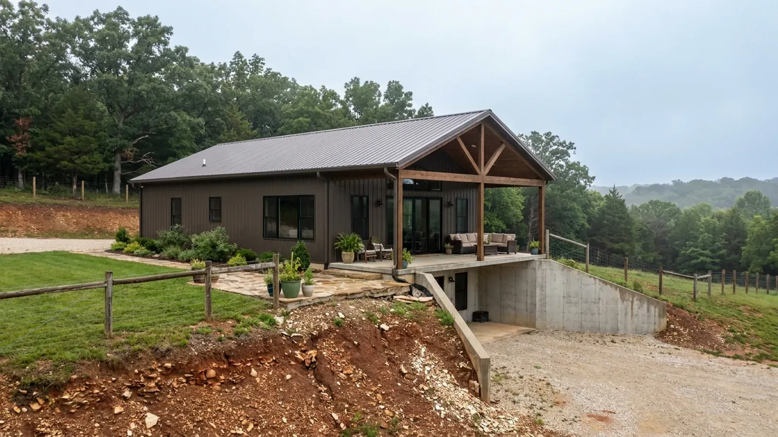
Barndominium with a Basement in Missouri
A basement is the one addition to a post-frame or steel-frame building where the arithmetic genuinely changes from one Missouri county to the next. The deeper the frost line a jurisdiction publishes, the shorter the step from a code-depth footing to a full foundation wall — and the sourced spread across Missouri runs from 15 inches in Sikeston to 36 in Kansas City. What decides it after that is site-specific: chert, a fragipan, a claypan with a winter perched water table, or a void nobody can see from the surface.
What actually changes with this feature
The look is the easy part. These are the decisions that follow from it.
How deep you are already digging
On a post-frame building the frost line sets the bottom of every post hole and every pier, so it is the number that decides how much of a basement wall you are getting for free. Kansas City publishes 36 inches in its own Table R301.2(1) at KCMO Code section 18-57; Lee's Summit publishes the same 36 at section 7-902 and then pushes water service pipe deeper still, to not less than 42 inches below grade at section 7-933. Boone County, St. Charles County, the City of Columbia, the City of St. Louis and St. Louis County all publish 30 inches. Springfield publishes 24, the City of Branson 18, and the City of Sikeston 15. Ask your building department for its Table R301.2(1) in writing before anyone prices an excavation — it is one page and it settles frost, snow, wind and seismic at once.
Ozark rock is not the obstacle people expect — chert and a fragipan are
The reflex answer for southwest Missouri is shallow bedrock, and the soil survey does not support it as a general statement. In the USDA-NRCS survey area for Greene County, bedrock restricts within 20 inches on only about 4.2 percent of the 433,836-acre survey, while in Taney County the same restriction reaches 37.9 percent — roughly nine times the difference, both inside what everyone calls the Ozarks. What you actually meet across Greene County is chert, with the dominant Goss soils carrying 5 to 75 percent gravel through every horizon, and a fragipan mapped on about 163,970 acres, roughly 38 percent of the survey area, at 16 to 33 inches. Springfield's published 24-inch frost line lands inside that band, which means a footing trench there very often terminates in or just above a dense, slow-draining pan. On a slope that argues for cutting into the hill for a walkout rather than excavating a hole, because a walkout turns spoil you were paying to haul into floor area and gives the lower level a drained daylight wall.
The voids nobody can see
Missouri's Department of Natural Resources has identified approximately 16,000 sinkholes in the state and says plainly that many more exist that have not been reported or documented — some not readily visible at the surface because the voids are plugged or capped with soil or thin rock, and discovered only during excavation, by drilling, or through geophysical exploration. That is a basement sentence more than a slab sentence. Density is a county question and the regional impression is wrong in both directions: a spatial query of DNR's own sinkhole layer returns 1,474 points in St. Louis County, 1,471 in Greene, 662 in Christian, 91 in Camden, 69 in Taney, 54 in Jefferson and 10 in Miller, against a statewide 16,001 that matches DNR's published figure. Two jurisdictions regulate it directly and the city is the stricter: Springfield's Flood Control and Water Quality Protection Manual allows a residential structure inside a sinkhole rim only at a 25-foot setback from the sinkhole flooding area and with a geotechnical investigation by a qualified professional engineer, where Greene County's 1999 Design Standards section 107 requires 20 feet and an engineer's statement on foundation suitability.
Clay, a winter water table, and the drainage a code may already demand
North and central Missouri is the other half of the problem. The Mexico series, whose national type location is in Montgomery County, is classified fine, smectitic, mesic Vertic Epiaqualfs — smectitic is the shrink-swell mineralogy and Vertic is the behaviour, stated in the taxonomy itself — with a claypan starting at 7 to 18 inches, very slow permeability, and a perched water table whose upper limit sits between half a foot and a foot and a half of the surface from December to May in most years. Boone County is one of the thirteen counties carrying the fullest claypan suite. Jackson County's dominant soils are smectitic and Vertic too, and nothing in the Jackson County Code fixes a presumptive bearing value, so allowable bearing under a footing there is a site question rather than a table lookup; Cass County by contrast writes 2,000 psf for typical clays into R401.4.1 by ordinance. Where a jurisdiction has thought about basements it says so in the code: Lee's Summit adds section 7-919 requiring under-slab drains wherever a foundation retains earth and encloses habitable or usable space below grade, section 7-918 requiring a sump at least 24 inches in diameter extending 24 inches below the basement floor, section 7-915 putting two No. 4 bars in basement foundation-wall footings, and section 7-916 setting column pads at a minimum 24 by 24 by 8 inches with three No. 4 bars each way.
The frost line is the hinge, and Missouri publishes no statewide one
Missouri has no statewide residential building code and no statewide frost depth, so the number that governs your excavation is whichever jurisdiction's own adopted table covers your parcel. Those tables do not agree. The Kansas City Residential Code at KCMO Code section 18-57 publishes 36 inches. Lee's Summit publishes 36 inches at Code of Ordinances section 7-902, and Cass County rewrote R403.1.4 at section 500.030 so that all exterior footings sit at least 36 inches below the undisturbed ground surface. Boone County's 2015 International Code Addendums, the City of Columbia, St. Charles County, the City of St. Louis and St. Louis County all publish 30. Springfield's adopted table publishes 24, Nixa and the City of Ozark publish 18, the City of Sikeston publishes 15, and Desloge in St. Francois County publishes 12 — eight miles from Farmington's 30, which is the sharpest pair on the whole list. That matters because a basement is not an extra structure bolted underneath a house; it is the same excavation and the same concrete you were already paying for, taken further. At 36 inches you are already most of the way to a knee wall before you have decided anything. At 15 inches you are not, and a basement in Sikeston is a genuinely separate line item rather than a deepening of one. Nothing about that is a Missouri fact. It is a jurisdiction fact, and it is the first thing to establish in writing.
Common ways to build this
Common configurations we see. Yours does not have to match one exactly — this is a starting point for the conversation, not a catalog.
Walkout lower level cut into a slope
1,800 sq ft main floor / 1,800 sq ft walkout lower level
The drawing that suits most sloping Missouri ground, and the one the Ozarks argues for specifically. Around the Lake of the Ozarks the Niangua-Bardley soils run 20 to 40 inches to dolomite with 15 to 70 percent chert gravel at the surface, against a 24-inch frost line in the lake towns — so the footing depth and the rock contact are frequently the same elevation, and cutting into the hill to reach a level bearing surface is work you were doing anyway. The daylight wall also solves the two things that make below-grade space unpleasant: natural light and a drained, gravity-fed exit for water.
Basement under the living wing only, shop at grade
2,400 sq ft shop at grade / 1,600 sq ft house over a 1,600 sq ft basement
The common shop-house compromise, and usually the cheaper one. The shop half wants a slab it can drive onto and does not benefit from being over a void; the living half is where the storm shelter, the mechanical room and the extra bedrooms are wanted. It also keeps the deep excavation inside one footprint rather than under a 40-foot clear span, which is where the temporary shoring and the column-pad detailing get expensive. Check your accessory-structure rules before fixing the split: several Missouri jurisdictions cap the shop against the house's floor area rather than against the lot.
Partial basement as a shelter and mechanical core
3,200 sq ft on grade / 600 sq ft below
A small excavated core under part of the plan, for the mechanicals, the well pressure tank and a hardened room. Worth knowing what this is and is not: a residential storm shelter in Missouri is a voluntary decision made on FEMA P-361 and ICC 500 criteria, not a permit condition. ASCE 7-22 introduced tornado loads in a new Chapter 32, and per the FEMA and NIST design guide those provisions reach Risk Category III and IV structures — a detached one- or two-family dwelling is Risk Category II and sits outside them. Build it because you want it, and price it as its own line.
Ways to build this size
A footprint can go together several ways. These are the service lines most relevant to it.
Custom Plans
Barndominium floor plans drawn to your parcel and your soil, and to whichever Missouri authority — a county, a city, or none at all — will review them.
Read moreSite Preparation
Clearing, grading, pad, drainage and access — plus the soil and septic evaluation that decides what a Missouri parcel can actually carry.
Read morePost-Frame Homes
Post-frame and pole barn construction built as a dwelling — with a straight answer on Missouri's farm-building exemption, a zoning exemption only.
Read moreBarndominium with a Basement: common questions
8 questions we get asked most often about this footprint. If yours is not on the list, ask it directly.
Does a basement even make sense under a post-frame building?
I am building in the Ozarks. Will I hit rock?
What is actually under Springfield if it is not rock?
How worried should I be about sinkholes?
Can I use a frost-protected shallow foundation instead of digging?
Do I need a radon system under the slab or basement floor?
Will the basement stay dry in Missouri clay?
What should I settle before anyone prices the excavation?
Want this drawn for your program and your parcel? That is where a build actually starts.
Start your plans
Tell us what you want to build and we will draw this for your program, then confirm what it looks like on your parcel, the wind load it has to meet, and a realistic budget range. That conversation costs nothing.